Paul’s Lane Loop – How long IS it?

The answer according to my Runkeeper track is 2.9 miles (4.67 km)…not 6km, not 7km either…and definitely not the stated 8km.  Would love to know who and how these trail lengths are measured?
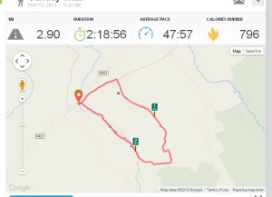
Runkeeper stats

Runkeeper stats

However, although Paul’s Lane Loop disappointed me with regard to not being as long as I’d hoped, it really was a fabulous walk – with a huge diversity of trail types and habitats to walk through, and some good uphill pulls to get the legs and lungs working hard.  At times it is rough going though, so you definitely need good boots with ankle support.

You start off uphill (of course!), heading up a quiet country lane.  After a while you turn right, continuing uphill, on a reasonably good gravel track, which soon turns into a very rough and uneven track…and continues to head upwards, until it narrows further to become a path.  I did stop a few times to catch my breath rest my legs look back down the hill and see how far up we’d come, but on the whole I was really pleased with how I felt physically and how I coped with the first 1½ miles of this outing, which was so far all uphill.

As the path eventually levelled out a few of the promised derelict remains of Bordingstown came into view.  Bordingstown was once a small village, abandoned during the Irish famine. Now all that remains are the ruins of old stone cottages, fallen down stone walls showing property boundaries and perhaps stock enclosures…and the most stunning wild fuchsia!  I wondered if the track we had just climbed was once the main route for the residents of Bordingstown to travel down to the trade routes or work in the mill found in the nearby village of Cadamstown.  The more I explore the Slieve Blooms, finding all these tucked away, largely forgotten old homesteads and townlands, the more I’m re-discovering my love of Irish history and nurturing a new-found respect for the everyday hardships of life back then.

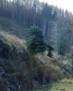
Not far past the crumbling cottages we came across what I can only describe as a field.  Looking a little out-of-place, here on top of a hill in the Slieve Blooms,and surrounded by coniferous Coillte plantations.  It was an almost perfect triangle, with a stone wall boundary on each side, accompanied by straight lines of magnificent beech trees.  It was a clean sward of grass, with no encroaching field weeds or tree saplings.  It looked as if either someone tended it, or it was naturally keeping itself in that state?  It almost looked like it had been lifted from some large, lowland country estate, and landed here on top of a hill, in the middle of nowhere. I would love to know more about this, and about Bordingstown in general.  I assume the field is still part of the former village of Bordingstown.  The beech trees gave the area a look of grandiosity that to my mind didn’t seem in keeping with the small townland that Bordingstown seemed to be.  Although, of course, if the beech trees were here in the times when Bordingstown was presumably a flourishing townland, then they are at least 170 years old, and may not have been so tall back then? (Wikipedia’s page on beech trees intimates that, whilst beech is not native to Ireland, they were widely planted in the 18th Century, so these particular beech trees maybe nearly 300 years of age) The mighty Google has yielded nothing so far on the history of this little area, so I feel a trip to my local library is on the cards!
Just one more aside, although I’m sure you’re already bored with my raptures about these grand old trees, this website claims an informal way of judging if these beech trees could be classified as ancient (300+yrs) is to ‘hug’ them!  If they measure ‘2 adult hugs’ then there’s a good chance they could date back to the 18th century.  After my planned history-digging trip to the library, I feel a tree-hugging hike could be on the cards…me, a tree hugger…never thought Id say that!

These beech trees were physically the high point of the trail (and for the obviously secret & apparently suppressed tree-hugger in me, they may well have been emotionally the highpoint of the trail too!), and from here on the trail took us gently downhill.  Down off the top of Magherabane, and down to meet Purcell’s Brook.  We did keep a look out for the swinging gate at the head of an old mass path that we were meant to pass by, but we didn’t see it.  I think this section may have been re-routed at some point, so its possible the trail doesn’t go near it any more, or just as likely, we were totally blind to it, and walked straight past it!  We did spy amazing little groups of tiny mushrooms and fungus, making the forest floor, under the close-packed pine trees, look a little like a secret fairy underworld.

As we neared the brook we were met by an old man, standing by a quad bike with a rifle, staring out across the valley to our left.  We’d recently been re-watching RTE 1’s excellent Love/Hate series, and a mad rush of completely irrational thoughts raced through my head.  The husband manfully took the lead and told me to stay back.  However, we walked straight past him, he still had his ear-defenders on, and I honestly don’t think he was even aware we were there.  I glanced back as he walked over the small bridge nearby and headed off into the thick cover, up the other side of the valley.

The path brought us to a gateway, which lead us to open land by the banks of the Silver River, and the beautiful Silver River waterfall.  A section of well-constructed stiles, and short section of extremely slippery boardwalk guided us alongside the river and back into woodlands.  I cannot emphasise just how slippery the boardwalk was.  Whatever had been done to it to make it non-slip had seemingly made it worse.  The damp weather was undoubtedly contributing to its slick surface.  Even Monty with his leg-at-each-corner and dog pad grips was sliding about as if he was on ice, and the husband and I found ourselves gripping the much-needed handrail to stay upright.

The path took us uphill again, at some points purpose-built wooden steps had been put in, and at other points we picked our way through trees, with no obvious path to follow.   As you can imagine, my thighs absolutely loved the steps…especially the one’s that were just that little bit too high and/or too far apart to get a good ‘stair’ rhythm going.  However, all whingeing aside, the steps made what would likely have been a slippery, rooted uphill scramble much easier to negotiate, so I really cannot complain.  All the while, the Silver River ran along side us, now starting to cut through large rocky areas.

We took a mini view-point diversion across a bridge build for just that purpose.  An information board gave a little geology information on the area, and on the Silver River in general.  A couple came to the info board from the opposite direction, both wearing jeans and trainers and looking very clean, so I surmised that we couldn’t be too far from Cadamstown at this point.  Monty took a dislike to the gentleman (he’s a strange little dog sometimes!) and so we felt we couldn’t stop to read the board properly, and instead we continued back up to the main path and left the couple in peace.  Another set of wooden steps soon made an appearance and my poor thighs all but wobbled just looking at them.  I do believe I swore out loud at the thought of climbing yet another set of steps, and was mortified to find the couple not too far behind us, certainly close enough to have caught every syllable of my outburst!  To add insult to injury, at the top of the steps was a tall stile.  With legs of lead, but not wanting to embarrass myself further I grunted and groaned, and clambered over it to find ourselves in a farmer’s field.  Conscious that we had a dog with us, I did a quick scan for cattle, and then we continued down the path, right through the middle of the field.  The couple soon over took us at a very quick march, no doubt keen to get as far from this uncouth, potty-mouthed Curvy Hiker as they possibly could.

As we got closer to the gate at the bottom of the path, I was dismayed to see a rather large padlock on the gate….dismayed, not because the farmer had locked the gate, but because the stile to the side of it was simply a stone wall with a very narrow gap in it.  There was, inevitably, the comedy moment where I got stuck…and the husband was laughing too much to help me.  Fortunately for him, at this point I was laughing too!  I had already dropped my backpack off, and lowered it over the gate.  And I was slowly removing my clothing, layer by layer, in order to squeeze myself through.  Obviously these stiles aren’t designed for Curvy Hikers, and in my defence, the naturally slim husband did also find he had to breathe in, and lift up the bottom of his jacket, to get through.  I’m here, typing this now, from the comfort of our cottage…so I obviously managed to both unstick myself from the stile, and get through it eventually, but my escape efforts were very much hindered by my own laughter at the ridiculous situation!  I did manage to get through without stripping off completely thank goodness!

A little sad to see on the other side of the stile a sign stating ‘No Dogs Allowed’.  At no other point on this loop trail did we see any sign stating No Dogs, including the stile at the top of the field as we entered it.  And, indeed, on getting back to the car park, the sign board with the Loop map on it clearly states only that dogs should be kept on leads, and doesn’t state that dog’s aren’t allowed.  I know full well the issues with dogs and livestock, as well as the dangers of walking through cattle with dogs, and had instinctively looked for cattle as we entered the field.  I may think twice about repeating this walk during the summer, when the stock are likely to be grazing, and/or doing it with one of our bigger dogs who I couldn’t easily pick up and carry if I found myself in a field with cattle.  My dogs are nearly ALWAYS on leads, regardless of whether they are stockproof or not, so livestock worrying is less of a concern for me.  However I did feel bad, having walked across a field, blatantly with a dog, to find a No Dogs sign at the lower entrance.

The last section is a short stroll down the lane, back to the car park, and my well-earned flask of hot tea.  The walk hadn’t been as long as I’d have liked, or indeed had hoped for…but Paul’s Lane Loop packs a hugely varied range of scenery, landscapes and features into its 2.9 miles, and is well worth doing!

November 2013

Enhanced by Zemanta

Good disappointment!

During a previous visit to the Ridge of Capard back in the Summer I recalled noting that the ‘longer’ route, on the Info Board in the Car Park, was 4km, and that the estimated walk duration was 2 hours.  I remember thinking that whilst 4km wasn’t much in distance, if the powers-that-be reckoned it should take 2 hours to complete that loop, then it must be a fairly challenging trail.

The Weather Gods aligned with the Time-Off Gods, giving us both a free Sunday, with fabulous weather, and a yearning to get our hiking boots out in the air again.  It was going to be a coin toss between going back up to the Ridge of Capard (I’ve been dying to show the husband the views from up there!) and an 8km loop walk I’ve been eyeing up for a while.  However the coin toss was no longer required when my printer spat the dummy and spewed the contents of its colour cartridge all over its internals.  Being the self-styled Queen of Over-Preparation I didn’t want to walk in an unknown area without a copy of the route and trail description, so the decision was made to head to the ridge.

The trail starts off on the familiar wooden boardwalk.  We took a small diversion up to the viewing point, and spent 5 minutes taking photographs of family groups for visiting tourists, before discretely heading off on our intended walk, without really getting a chance to enjoy the 360° views.

At the point where my previous walk route went through a gate and followed the Slieve Bloom way up over the ridge, we followed our chosen route along a gravel track.  Soon enough we came to a locked metal gate, and a metal ladder stile. I was anxiously thinking of the best way to get a 20kg, wriggling, squirmy Dolly up and over the stile (those steps are NOT very dog friendly!) when I spied a gap in the wall over to the right.  There was a bit of scramble over rocks, logs and through brambles, but it was still easier than trying to get a big dog over that stile.

The beautiful Glenbarrow valley opened up below us, and the track descended gently into it.   The info board had warned of keeping clear of ruined buildings and stone walls, and we soon came across the remnants of old stone cottages and what we assumed were small stock enclosures.  A small cottage came into to view on the left, with a small plaque on the outside wall:

Ann Clear's cottage plaque

According to this webpage, The Cones, was once home to a number of families that survived this bleak landscape. After the Irish Potato Famine, their numbers decreased from about 12 families in the 1850s to 4 families after 1911.  It is hard to imagine how anyone could scratch a living from the land around here, and I have to remind myself that these tree plantations are relatively new, and the landscape would have looked quite different back in the day.  Naughty I know, but we ignored the sign warning us to stay away from the unstable building, and had a quick peek inside.  I tried to imagine the tales that were told, sitting around the fireplace in the evening.  The views that might have been seen, down the valley, through the window.  And the lives that had passed through that cottage’s history.  I could have stayed there all day, letting my nostalgic imagination run wild, but the husband and the dog were keen to move on.

Shortly before turning sharp right, we came upon the magic tree.  Even when we were right up close to it, it was difficult to see just how it was growing at all.  It seemed to be floating in mid-air 🙂

Magic floating tree

The trail took us through a section of forestry, and then a long uphill section.  The communications mast near the car park (The Metal Man) came into view sooner than I expected, and a right turn on the trail brought us to some wooden steps…which my poor, tired thighs didn’t thank me for at the time.  The steps went over the top of a bank, and then a small section of boardwalk allowed us to traverse a small boggy, spring.  A short section of easy, flat trail brought us all too soon back to the car park!  I didn’t want to stop, really I didn’t.  I felt barely warmed up, and simply couldn’t believe we were back at the car already!  However, I knew there was a trig point somewhere near the car park, so whilst we stopped momentarily at the car for the husband to remove a layer, I double checked the OSI map again.  Back down the lane, and a left turn up a soft track brought us to quite possibly the easiest summit-top trig point.  You could pretty much drive to it if you so wished.  Breath-taking views however, and it added about a quarter of a mile onto our walk.  After a quick cup of hot tea, whilst watching a large bank of rain clouds heading in our direction, we legged it home to light the fire…

Tea with a view

I really enjoyed that, but I’m a little disappointed that it wasn’t longer or more challenging“…are words I would never have said about walking ANYWHERE a year ago!  Let alone out on the Slieve Blooms, so I allowed myself a slightly indulgent smile and reflected on the fact that my disappointment was a good thing in this instance.

From a recreational point of view – a lovely walk in a beautiful spot, on well-maintained tracks, with breath-taking views.
From a personal point of view – I wanted to breathe harder and for my muscles to hurt more…

Of course, I had hoped to make use of having a free Sunday this coming weekend, but the weather forecast is looking woeful.
Don’t get me wrong, I don’t mind bad weather…but finding waterproof over trousers to fit me is a complete non-runner so far.  Therefore walking in heavy rain will just have to wait until I’m slimmer!

…Cool woods

The evening before, we had visited the stunning Ridge of Capard.  It was late afternoon when we got there, and we simply ran out of time to fully enjoy the area.

Throughout our walk along the Ridge I had been telling Mum about the beautiful Glenbarrow falls in the valley below us, and the curious rock formations at Flat Rocks…and the satisfaction (for me!) of getting to the top of the steep section half way around.

With all this in mind, we gave more thought to planning our day trip out, and giving ourselves as much time as we felt we needed.  With our morning chores done, and with our sandwiches packed, we headed for Glenbarrow.

We had a very quick diversion to Cathole’s Falls…we’d seen the signposts on our travels the evening before, and this was another place that I’d never visited.  Once again, I mentally added this location to the never-ending list of places I want to come back to, but today we had other plans, and so after a short wander, and a little toe-dipping, we hit the road and pressed on to Glenbarrow.

I had waxed lyrical about the peace and quiet of the Glenbarrow area…and with it being mid-week I fully expected us to be the only ones there.  But TWO coachloads of schoolchildren soon dissuaded me of that idea.  Filled with the excitement of nearing the end of term, and the end of their school year, they were enjoying a day trip out.
Oddly though, and perhaps fortunately (if I’m allowed to say that?), they were loading up onto their coaches and heading away to their next destination…so we would have peace and quiet on the trails after all.

Ireland was still in the grip of a mini-heatwave, and it was ridiculously hot.  I suggested to Mum that we walk as far as the falls, and see how both we and the dogs were coping with the heat, before we decided whether to carry on or turn back.  The trail from the car park to the Falls was mostly through tree cover.  Once we pressed on from there we’d be heading towards trail sections that were in the open and afforded little shade for us to rest and cool down in.

We weren’t hunting for Geocaches this time, so we came across Flat Rocks much quicker than I’d remembered rom before.  With proper boots on this time I had much better grip on the wet rocks too.  Dolly loved being able to paddle in the shallow river sections on the rocks, and the moving water gave us a great opportunity to safely water the dogs without using up our own water resources.

Dolly on Flat Rock

The Falls themselves looked significantly different due to the lack of recent rainfall.  We found a path that almost allowed us to get into the river bed, up to the base of the Falls.  No way we could have done that on our previous visit.  I was saddened to see that a relatively recent visitor had deemed it appropriate to throw their banana skin into the falls.  Would it have been SO difficult to take their rubbish back home with them?  Judging by the freshness of it, it hadn’t been there long.  Perhaps the culprit would do well to remind themselves of the principles of Leave No Trace.

Spot the banana skin...

Spot the banana skin…

The dogs were coping well with the heat, the woods had done a great job in keeping us cool, and so we pressed on.  I wish I’d taken more photographs of our day out, but sections of the path ahead had been so muddy as to be almost impassable the last time I’d gone up here.  However, this time they were rock hard and bone dry, quite a contrast!  And much easier to walk across!  At the bottom of the dreaded ‘steep section’ we stopped to water the dogs.  Knowing that once past this spot we would be going steeply uphill, and out under the glare of the sun.  I also wanted to talk to my head about going up this steep section.  It IS only short, but it is steep (even the map calls it steep!) and I find the uneven steps at the beginning of it to be real leg-killers.  Imagine my delight at getting to the top of the section without stopping!  I won’t say I wasn’t puffing, panting, bitching and moaning…but I got up there, and I didn’t stop on the way.  And for me, that’s a small victory!

The steps to Hell

The steps to Hell

We found a tree to hide in the shade under whilst we watered the dogs, watered ourselves, got my breath back, and then we carried on along the trail.  I swear my stride had a little bounce of confidence in it, as we walked along. Smug isn’t the word I’m looking for, but I was more than a bit chuffed that I’d faced the dreaded ‘steep section’ and got  to the top relatively easily!

I had explained to Mum about the last time we did this route, and how I thought we’d taken a wrong turning.  If she was willing and up for it, I wanted to try to find the correct route, but it might a fool’s errand and it may involve turning back and re-tracing our route, back to the path that I knew would take us back to the car park.  Arriving at the junction where the route arrow points straight on, but the route map suggests we should turn right….we turned right.  And we walked.  and we walked some more.  And then we walked a bit further.  And then I got out my OSI map, and tried to work out where we were.  Where I thought we were heading, and how closely the OSI map, and our current position, correlated with the loop route map I’d snapped on my camera phone.  Fortunately my navigational skills learnt during my time with the Venture Scouts didn’t let me down.  I know I’d need a refresher course in Navigation to get myself out of trouble in the fog on a hill top…but on a clear sunny day, with fairly easy landmarks to distinguish, I soon pinpointed exactly where we were and which direction we were heading in.  By my reckoning, at the next left curve there should be a path off to the left.  I promised Mum that if there was no path, I’d give up on finding the ‘correct’ route, and we turn back and stick to the route I knew

The track started curving to the left,  The trees to our left were coming to an end, and the land ahead was opening up to be flat heathland.  And there, hidden in the undergrowth on our left, was an ‘easy-to-miss’ finger post with a route arrow on it….bingo!  Between two trees there was a narrow path taking us into deep, dark woods…we were getting hot and sweaty at that point, and those cool, dark woods could not have been more welcoming!

Deep, dark woodland path...

Deep, dark woodland path…

I was confident this was the correct path, but reassured Mum that even if it wasn’t it was heading in the right direction, and I would ensure we got back to car park…getting lost on the New Forest, just me and my horse, and finding new ways to get home had been a favourite hobby in my youth, and had given me a reasonably reliable sense of direction!

It was downhill all the way.  Steep in some sections, rough in others.  We required our poles a few times to negotiate some awkward sections, and I wouldn’t fancy it if the ground was wet or slippery…indeed Dolly and I had words a couple of times to ensure she wouldn’t pull me off-balance in her enthusiasm to explore & sniff at the limit of her Flexi lead…but it was deep, dark, silent and magical…and reminded me of exploring long-forgotten areas of the New Forest.

Soon enough, the path brought us along side a fence, which in turn dropped us down to the forestry barrier, taking us down the lane back to the car park.  The car park was empty, so I moved the camper van in under some trees, and opened all the doors to cool it off, whilst we enjoyed mugs of hot tea (humans) and bowls of cool water (canines).

I was delighted that I had got up the steep section, which had so frustrated me on my previous visit, much more easily.  Some of that was from my head knowing where the end of the ‘up’ bit was, and also, I hope, because my fitness is improving.  I was also pleased that we had also found the elusive correct trail, so the distance on my Runkeeper app corresponded more closely with the trail length on the route map, and I’d got to walk through some fabulous dark forest.
I wonder would I be brave enough to do the same forest section, in the dark…hmmm…maybe a Halloween Night Hike….well, I do get a perverse joy in deliberately scaring myself sometimes! Yet another “I want to do that” to add to my mental list.

We had enjoyed a really lovely walk, in a beautiful area, on a really hot day, and made the most of the gorgeous cool woods.


A little deja vu in the Silvermines.

I recognised the car park as soon as we pulled into it.  I’d been there before.  I think we parked in almost the exact same spot too!

01 Welcome

The last time that both my parents had to come over to stay with us I had taken them on a scenic drive around the Silvermines and Keeper Hill.  We’d stopped off in Toomevara, and purchased the makings of a picnic, and then we’d headed up into the hills.  Driving of course, not walking!  We’d stopped at this same car park, facing the majestic Keeper Hill, and we’d scoffed our picnic lunch whilst plotting on the road map the places we’d like to visit next.
Back then, if you’d suggested to me to get out and go walking for a couple of hours…well, after I’d finished chewing my mouthful of sandwich (good manners cost nothing!) I’d have either laughed at you, or sworn at you, or quite possibly both (good manners out the window at such a preposterous suggestion!)…but this time I was itching to get out, to get my rucksack on and to get going.  Still, I did take a small moment to cherish the memory of a happy day spent here driving around these hills with my late father.

We set off down a gentle slope out of the car park and hesitated briefly at the first junction until we spotted the arrow marker we were meant to be following.  We continued heading downhill, past an area of trees apparently planted by the Irish American Cultural Institute, and memories of the never-ending ‘uphills’ kept trying to crowd to the forefront of my mind.  The stunning views of Keeper Hill, opening up in front of me, tried their hardest to distract, but I knew that at some point all this ‘downhill’ would inevitably lead to the trail heading uphill.  At a Y junction, continuing downhill did look tempting, but that trail would have taken us in completely the wrong direction and so we turned uphill.

Monty & Keeper Hill

Monty & Keeper Hill

We did stop fairly shortly after starting the ascent, but only (truly!) because I’m trying to get into the supposedly good habit of drinking water every mile.  I find if I don’t make a point of telling myself to drink water, I don’t drink any at all.  And then when my head starts banging, well its too late really.  That dehydration headache has set in, and it’s just not going to shift itself.

The first half of the ascent didn’t seem too bad.  I still stopped for breaks more than I wanted to, struggled with not being able to ‘keep going’.  However the views across to Keeper Hill were fabulous, and spotting a couple of ponies ‘fly grazing’ in the bushes on the slopes below us, meant that when we stopped I could pretend I was stopping to admire the view.  The husband isn’t gullible, but he humours me.  At one point, we came across a big puddle full of frog spawn and tadpoles.  Alas, we couldn’t investigate further as a couple with an unruly labrador came down the hill towards is.  Their labrador and Monty very quickly decided they didn’t want to be friends.  So it was easier to just pick Monty up, hold him out of reach and to carry on up the hill away from them.

Ponies 'Fly Grazing' on the mountain

Ponies ‘Fly Grazing’ on the mountain

We stopped for snacks at the end of the forest track, and contemplated the steep section of muddy path ahead of us.  Once again I found myself looking up at the summit of Keeper Hill and being more and more determined to get fit enough to get up there soon!  We also looked across from where we were to the Silvermine’s West Top & Far West Top.  I knew realistically that I wouldn’t be up to getting there today, but I did think a diversion up to the West Top looked tempting and that I’d give it some more thought whilst we did the next trail section…so perhaps all the struggling I’m doing on ascents isn’t messing with my head so much after all, for me to even contemplate something like that as an option?

Keeper Hill (Sliabh Coimeálta)

Keeper Hill (Sliabh Coimeálta)

However, after pushing on up a short but steep section of mud, out onto a good, hardpacked trail…I looked towards our return path home and realised that if we diverted up West Top I would never have the legs to also go up East Top on the return leg, and thus we’d never get home!  I don’t think even the mountain goat husband expected the home-bound route to be as steep as the next section was!  Two walkers were just coming down off East Top and heading off up to West Top, and they paused to ask how we’re getting on.  Between breaths I said all was good but I was struggling, to which he replied that if I’d got this far, up the trail we’d just walked, then I couldn’t be doing too badly!  I sincerely doubt he has a clue how much that comment perked me up!  It certainly helped me pick up and walk in the direction of what looked like a vertical path, knowing I would get up there, even if I did find I was stopping almost every 20 strides to whisper sweet nothings to my extremely angry Achilles tendons!

Far West Top

Far West Top

The photo really doesn’t do it justice, it was steep enough, that standing upright at some points I could reach forward (without leaning forward) and almost touch the path in front of me!  But I took it in short sections, stopped for leg breaks when I needed them, and I got up there…I was gasping for breath and swearing loudly, and internally I was fist pumping too. My celebrations were a little curbed by two other walkers having a picnic in the heather just off the trail.  We swiftly walked on.

Path up to West Top (the first two 'roller coaster' bits are just teasers, 'warm-ups' if you like!)

Path up to West Top
(the first two ‘roller coaster’ bits are just teasers, ‘warm-ups’ if you like!)

View from West Top across to Far West Top

View from West Top across to Far West Top

The easy way back to the car park would be to have followed the forestry track around to the left, but our trail markers pointed straight on…into a bog…and so, straight on, into the bog we went!  It had been fairly dry recently, I wouldn’t want to attempt this section of the trail after any significant rain.  Not only would it be highly unpleasant (hey, I grew up on the New Forest and I cut my walking and riding teeth on bogs, but this was just deep, wet, gloop!) but the amount of additional damage you’d do to the ground trying to pick the driest route through it would hardly make it worth the effort.

22 Boggy

We came out of the bog and onto a slightly overgrown firebreak.  It was a steep enough descent in sections, and the path got a bit rough in parts.  However, alternative routes through the undergrowth had been made by previous walkers, and a few wheel marks showed that mountain bikers must have been this way recently too.  I slipped at one point, and once again landed on my arse in a patch of wet mud (thank DoG for dry clothes back at the car!).  I’ve finally bought myself a pair of boots, but I’m still at the ‘wear them at home on carpets’ stage, until I decide that they do fit well and are comfy, even when my strange feet swell in their odd ways.  But trails like this are just beyond the limitations for my walking shoes, I need better grip on the slippy stuff, and my feet and ankles need better support on the rough stuff!

Firebreak

Firebreak

The firebreak eventually deposited us back on to the trail section, less than 300 metres from the car park.  Thankful to be back on level, firm track we picked up the pace back to the car.  I was smiling to myself  inside, because when we set out on this loop walk, I was mildly horrified that the last section back to the car would be uphill, and I remember thinking that was really unkind and would be hard work on tired legs.  But now, after the few steep sections we had just tackled, it barely felt like a slope at all…pah, call that a hill!

Dry trousers, dry socks, comfy crocs, and a cup of tea!  The perfect end to a great walk in a beautiful spot.

26 Dry clothes and tea