
During a previous visit to the Ridge of Capard back in the Summer I recalled noting that the ‘longer’ route, on the Info Board in the Car Park, was 4km, and that the estimated walk duration was 2 hours. I remember thinking that whilst 4km wasn’t much in distance, if the powers-that-be reckoned it should take 2 hours to complete that loop, then it must be a fairly challenging trail.
The Weather Gods aligned with the Time-Off Gods, giving us both a free Sunday, with fabulous weather, and a yearning to get our hiking boots out in the air again. It was going to be a coin toss between going back up to the Ridge of Capard (I’ve been dying to show the husband the views from up there!) and an 8km loop walk I’ve been eyeing up for a while. However the coin toss was no longer required when my printer spat the dummy and spewed the contents of its colour cartridge all over its internals. Being the self-styled Queen of Over-Preparation I didn’t want to walk in an unknown area without a copy of the route and trail description, so the decision was made to head to the ridge.
The trail starts off on the familiar wooden boardwalk. We took a small diversion up to the viewing point, and spent 5 minutes taking photographs of family groups for visiting tourists, before discretely heading off on our intended walk, without really getting a chance to enjoy the 360° views.
At the point where my previous walk route went through a gate and followed the Slieve Bloom way up over the ridge, we followed our chosen route along a gravel track. Soon enough we came to a locked metal gate, and a metal ladder stile. I was anxiously thinking of the best way to get a 20kg, wriggling, squirmy Dolly up and over the stile (those steps are NOT very dog friendly!) when I spied a gap in the wall over to the right. There was a bit of scramble over rocks, logs and through brambles, but it was still easier than trying to get a big dog over that stile.


The beautiful Glenbarrow valley opened up below us, and the track descended gently into it. The info board had warned of keeping clear of ruined buildings and stone walls, and we soon came across the remnants of old stone cottages and what we assumed were small stock enclosures. A small cottage came into to view on the left, with a small plaque on the outside wall:

According to this webpage, The Cones, was once home to a number of families that survived this bleak landscape. After the Irish Potato Famine, their numbers decreased from about 12 families in the 1850s to 4 families after 1911. It is hard to imagine how anyone could scratch a living from the land around here, and I have to remind myself that these tree plantations are relatively new, and the landscape would have looked quite different back in the day. Naughty I know, but we ignored the sign warning us to stay away from the unstable building, and had a quick peek inside. I tried to imagine the tales that were told, sitting around the fireplace in the evening. The views that might have been seen, down the valley, through the window. And the lives that had passed through that cottage’s history. I could have stayed there all day, letting my nostalgic imagination run wild, but the husband and the dog were keen to move on.


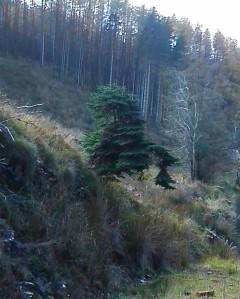
Shortly before turning sharp right, we came upon the magic tree. Even when we were right up close to it, it was difficult to see just how it was growing at all. It seemed to be floating in mid-air 🙂
The trail took us through a section of forestry, and then a long uphill section. The communications mast near the car park (The Metal Man) came into view sooner than I expected, and a right turn on the trail brought us to some wooden steps…which my poor, tired thighs didn’t thank me for at the time. The steps went over the top of a bank, and then a small section of boardwalk allowed us to traverse a small boggy, spring. A short section of easy, flat trail brought us all too soon back to the car park! I didn’t want to stop, really I didn’t. I felt barely warmed up, and simply couldn’t believe we were back at the car already! However, I knew there was a trig point somewhere near the car park, so whilst we stopped momentarily at the car for the husband to remove a layer, I double checked the OSI map again. Back down the lane, and a left turn up a soft track brought us to quite possibly the easiest summit-top trig point. You could pretty much drive to it if you so wished. Breath-taking views however, and it added about a quarter of a mile onto our walk. After a quick cup of hot tea, whilst watching a large bank of rain clouds heading in our direction, we legged it home to light the fire…

“I really enjoyed that, but I’m a little disappointed that it wasn’t longer or more challenging“…are words I would never have said about walking ANYWHERE a year ago! Let alone out on the Slieve Blooms, so I allowed myself a slightly indulgent smile and reflected on the fact that my disappointment was a good thing in this instance.
From a recreational point of view – a lovely walk in a beautiful spot, on well-maintained tracks, with breath-taking views.
From a personal point of view – I wanted to breathe harder and for my muscles to hurt more…


Of course, I had hoped to make use of having a free Sunday this coming weekend, but the weather forecast is looking woeful.
Don’t get me wrong, I don’t mind bad weather…but finding waterproof over trousers to fit me is a complete non-runner so far. Therefore walking in heavy rain will just have to wait until I’m slimmer!

Only 20kg to get over/under/through a stile! Beginner! Maisie at her heaviest was about 39kg! 😆 It’s amazing how creative you can become. It never ceased to amaze me how flat she could go and get under 9″ clearance at a fence. Don’t know if the new pair could be that creative…still there’s time yet.
Always wary of stated walking times. Used to have a game beating times for Munro ascents given in the Scottish Mountaineering Club book. Some were ridiculously overestimated. My granny could get up the hills faster than some of their times – and she passed away in ’88. Still, from your photos, it looks like it was a very interesting walk in any case.
It can be a tricky thing trying to find a walk that gives the challenge you want without being overwhelming. I have to admit at 4km total I’d be looking for something very uphill if I was going to take 2 hours. Eg For rolling tracks and paths I tend to allow 4km/hr pace and if it’s serious bog or steep uphill 2 to 2.5 km/hr pace. I then tag in 30 minutes for lunch. Then I build my walk from that. By working out distance and time for myself from maps I’ve a much better idea of how the walk will be.
Thanks Ken
I’m going to have to practice my dog-hefting I think, if we’re going to be coming across this style of stile more often….or just bring the jack russells instead haha! I also think the new Labrador Security Co will surprise you regularly with their own unique brand of creativity 🙂
I’m definitely learning to be more wary of stated walk distances too! We did an “8km loop walk” last weekend that came in at just over 4½ km on completion (blog post on that walk coming soon!). The walk took us over some varied terrain, up and down some relatively steep sections, through several diverse habitats, and was a really lovely walk…but I really, really want to get some distance into my legs this winter, and I confess I felt a little cheated afterwards. (DoG I must sound like such a moaner!)
I think its possible that I may need to brush up my navigation skills, and just head out off-the-beaten track…or get brave and try out some of the ‘hard/difficult’ graded loops?
I tend to find that most walks in books etc. (and here I mean walks not specifically hillwalks) given a hard or difficult rating tend to be rated for total beginners who may be incredibly unfit, i.e. for the lowest common denominator. Given your experience I would suggest you give more “difficult” walks at least a try. I’ve been in mountains where, having read over the route beforehand, I have found the alleged difficulties near non-existent and obviously written “on the safe side”. As long as you follow the golden rule “don’t be afraid of turning back (for whatever reason) – the mountains will always be there.”
That makes a lot of sense!
I’ve re-jigged my “list”, and added some of the less scary sounding ‘hard/strenuous’ graded routes – can’t hurt to try!
Thanks Ken 😉